


Download PDF (14.29 MB)
Title: Joshua Tree Brochure
Date: 2024-10-19
Author:
Description:
| Title | Joshua Tree Brochure |
| Date | 2024-10-19 |
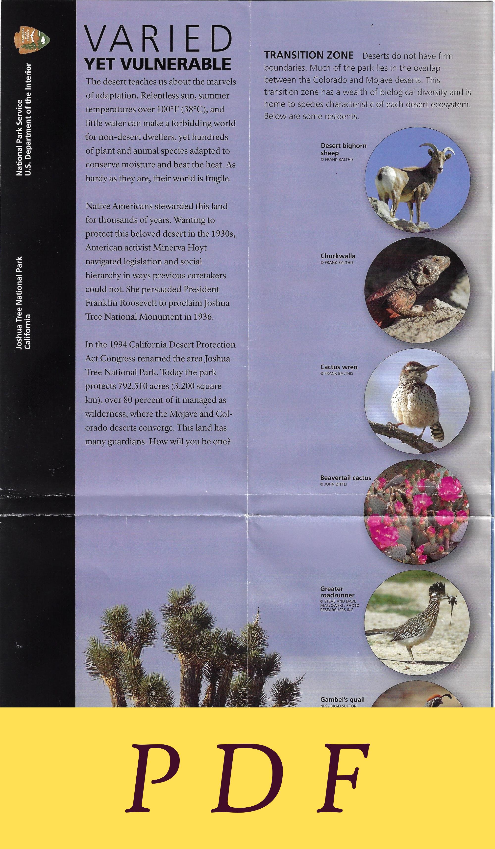
| Description | V R | E D TRANSITION ZONE Deserts do not have firm YET VULNERABLE boundaries. Much of the park lies in the overlap _ The desert teaches us about the marvels between the Colorado and Mojave deserts. This transition zone has a wealth of biological diversity and is home to species characteristic of each desert ecosystem. Below are some residents. of adaptation. Relentless sun, summer temperatures over 100°F (38°C), and little water can make a forbidding world for non-desert dwellers, yet hundreds Desert bighorn of plant and animal species adapted to sheep : © FRANK BALTHIS conserve moisture and beat the heat. As hardy as they are, their world is fragile. Native Americans stewarded this land for thousands of years. Wanting to protect this beloved desert in the 1930s, American activist Minerva Hoyt | navigated legislation and social : ee oan hierarchy in ways previous caretakers could not. She persuaded President Franklin Roosevelt to proclaim Joshua Tree National Monument in 1936. In the 1994 California Desert Protection Act Congress renamed the area Joshua : Tree National Park. Today the park ca a protects 792,510 acres (3,200 square km), over 80 percent of it managed as wilderness, where the Mojave and Col-. \ orado deserts converge. This land has & many guardians. How will you be one? Beavertail cactus 4 © JOHN DITTL te Greater roadrunner -@ STEVE AND DAVE _ MASLOWSKI / PHOTO RESEARCHERS ING. Gambel’s quail - NPS/ BRAD SUTTON i MOJAVE DESERT Thewesternhalf of the park, Joshua trees, alive and dead, are home to many | ae Lh at elevations over 3,000 feet (914 m), is Mojave Desert animals including the Scott's oriole, red-tailed hawk, a habitat. Amid boulder stacks are pinyon pines,~__ladder-backed woodpecker, American kestrel, and junipers, scrub oaks, Mojave yuccas, and western scrub jay. The loggerhead shrike often | Mojave prickly pear cacti. The Parry's nolina = —_—sImpales prey on the Joshua tree’s sharp-pointed : y ee tall feathery sprays skyward. The | leaves. Gambel’s quail, perhaps with a string of ca skeletal blackbrush might look dead butis youngsters in tow, scurries from shrub to shrub. _ very much alive, shedding leavesinhot =. ue i: : i f | | months to retain moisture. __ Hidden in the rocks might be a red diamond | a | rattlesnake, its eyes on a desert spiny lizard, which _ | The wild-armed Joshua tree is trulyasign =| in turn Is searching rocks for insects. A marvel of | H\\ 7 you are in the Mojave Desert. It is not a desert adaptation, the pinacate beetle never drinks | GHAR leg ~ tree but a yucca species. Like other desert = = water but gets moisture by eating fungus and ‘ plants, its waxy, spiny leaves expose little _ decaying vegetation. It is known as a circus beetle | surface area, efficiently conserving moisture. | because, when threatened, it does a headstand” Joshua trees can grow over 40 feet (12 m) at a of while emitting a foul-smelling secretion. leisurely rate of one inch (2.5 cm) per year. _ Clusters of cream-colored flowers bloom February— In early morning or late afternoon a black-tailed | through April, then the tree grows its branches. Jackrabbit may race across the landscape. Gigantic | i i i i | ears help regulate its body temperature. In warm weather its blood vessels expand to release heat. When cold, they constrict to retain warmth. _ Parry’s | ae ILLUSTRATIONS—NPS / ROBERT HYNES ~ nolina American Joshua tree § kestrel ve ce Scrub oak | Juniper ~ Prickly. pear § lack-taile _ Jackrabbit Spe Ht rattlesna e COLORADO DESERT The eastern half of the =~ Animals display many forms of adaptation! park, less than 3,000 feet (914 m) above sea level, The Kangaroo rat gets water lies within the Colorado Desert. This habitat of the _ | trom its food: seeds, ee lower Colorado River valley is part of the much _ leaves, stems, and a ae th larger Sonoran Desert, which spans southern | |) ipsects. It cam store a Arizona and northwestern Mexico. Creosote _ food for weeks | in dominates this sun-baked bowl, punctuated here—_its cheek pouch. - and there by spidery ocotillo, green-barked palo Its large hind verde, and patches of jumping cholla cactus. teet adapted Jumping cholla is also called teddy bear cholla— = =~=~—« for hopping but don’t try to cuddle it! — | over desert | i sand, which it Intermittent water in washes and on hillsides 7 dees all night: sustains smoke trees and ironwoods. Wildflowers abound, Red-orange blossoms of the chuparosa attract hummingbirds, for which the plant Le is named, and the tiny checkerspot butterfly. Annuals including desert sand : verbena survive drought by living only Wh in spring and going to seed when iN conditions become harsh. Seeds can _ lie dormant for several years until conditions are again favorable. The kit fox, also” _ well-adapted to _ desert travel, may Ocotillo Dune primrose Sand verbena te eer Roads and trails lead through a ota sia ve i The granite continued to uplift and £/~ _ jumble of stacked boulders. How , | ! contacted groundwater. Chemical | did they get there? The rock piles | a ia weathering resulted and worked began underground long ago as a on the angular granite blocks _ result of volcanic activity. Magma— (right), widening cracks and in this case a molten form of rock rounding edges. called monzogranite—rose from deep within the Earth. It intruded 4 the overlying rock, the Pinto gneiss formation. The granite cooled and crystalized, forming horizontal and vertical cracks (joints; right). Eventually the surface soil eroded, leaving monzogranite heaps scattered across the land like piles of toy blocks (far. right). OASIS At the park's fan-palm oases you are atop a crack in the Earth’s crust. Geological faults crisscross the park area. Groundwater that hits a fault plane rises to the surface and creates conditions for an oasis. This lush, green area in the desert where water Is present provides a welcome refuge trom desert extremes. Dependable surface water nourishes vege- tation. Along with the majestic California fan palms are cottonwoods and mesquites. There may also be un-desertlike species, including orchids and amphibians. © FRANK BALTHIS ; The erat eA plant typical — ete of the Colorado Desert, © (Ceti Melero en Seale pe lier M RCL Creare oo rae + | North . : aH a To Vierorvie and (3) 3m 85k Joshua Tree National Park stewards of the land on which the |__ place. We pay our respects t | , l Ha) \ acknowledges the Maara’yam park now sits. We are grateful to the people past, present, an Su a a 5 Miles (Serrano), NUwU (Chemehuevi), have the opportunity to work emerging who have been he a lviatim (Cahuilla), and Aha Macav with the Indigenous people in this — since time immemorial. | (Mohave) people as the original Paved road Ranger station | ~ . , Copper Mountain own) Unpaved road Picnic area | ° 3071ft | 2728ft aro 4-wheel-drive road, WH Self-guiding trail \ oy | Joshua Tre high-clearance vehicles only U4 i Joshua Tree Visitor Center /#iles alia ac aa Hiking trail Drinking water | cee (62) via es | ie TWE Developed land (a Emergency telephone | ees x | Park ila 1. Indian Cove Oa ~ Canyon Road Oa TTT f:Tavat | hE Mile marker Campground | wi «itl Trail AltaLomaDr Ce o ee a i Banger Station P ills =n 1 Park Boulevard i ry | : | ors solic anime sop! er PI il.;. Te ae 10 Mile marker ‘A| Group campground cot r | Pinto Basin Road A (ecervatione reatired) YUCCA VALLEY / oem y Distance oo Medical facility i eS .8km indicator i) y A Fortynine Pa Backcountry trailhead | r Ly I Me Indian eae (permit required from Ng \ , x Cove www.recreation.gov) | " : ) Indian Cove 7 ee West | \ ey 2 \ Nature Trail ; ya's [ t L d7 | Entre nce Station ia \timited car ie = of?! | fl a A Parking({ Pies eo ] i. a 6 Cf Black \ 1 no he dit 4 4 bas _ ~f North I / DP BB fF Rock \é Y% il oh a 3 ! he Oe hie AEN i S K taal Payer SS ne ar a rtenareteeteereree © On Ue a ees ; Se So Maze t a i at —~ ete Fina seen try 3 ; a es oe ie 4 ; Pe 4 | a i West Side / YW CET ty Sf, | ro NS il UALS Seta ai ann | Fie WT ROODNT rail ui ian ait Pali SOe fa igfoot Tra 3 Wah Ua © \ a ve Willow Hole iil al a ee Sy{ \ Lah es lla \ | WG r j.\ UC \_us7 (ng camping) ls Me a \ trail ay > itt NA SS { So teen ' oS CaN 28 ” ; ie a le ~~ teas ; Me ety 4 i. ; a Black Rock ~ Kop / Panorama in a i wt i Nature Center \ Spey Trail «$0 Ou) a | Once Mo a ne f and Campground ca tt tle a : ey, | i 5677 3 Andy SE pk calles cy on Meena he. ag 2 ee ul y o, N igh clearance only 14.2km NY Boy Scout / Keys i Panorama ,14/9m" y gps Oe o\ @/ (Accessible by ranger- M \ * Ouail ‘ id f Street — Loop Trail fe ( \ Bh I : We guided prograin only) : ( + a NA Springs ® 4 a i a : \ ua ° | » Eureka Peak \ RAN jee uy see , Locked Barkey Dam \- O'Dell Road 1682 Se —<_T 4, ‘ ii ty \ Jen ( 4- le cf AR cull uN | {2 See Fe ce Salley v\ Roa 0) 4-wheel-drive an a . yA ten Keer aN rc mal Pie = 1, a : t Minerva Ho ff * f LO fy etic, ! , re ay ih ar py CS » Se ‘\ ‘ : ae e Hemingway, . if Chor a ae / r uke } j Op = \ ? i 1648m ta SS Ro My, inl 4, id J , if ) P fy ng! Ne, . Lovington \ Quail ogp rein e | Hidden Valley) YY, \ KA Str eet ah Os e cattl ludye uy we Sie came i sta Cf i 1 . « * Wee {sc ke st ay | nN 2.7km : Coe me ) Covington i coe LOST HORSE VALLEY Minerva Hoyt¥ ns PD ass i Ot. ate” Crest : } \ sa a ie Cap Rock S\ f° A Oyster oe A Wi ¢ \ ‘king Tra a i \ Ryan ¢@ ‘ l be aN y a Ryan Mtn ib \ Lae S Hi 5458ft a at e \ Y : \ i a { + as no ry ‘Tire 7. Le 1€5 : Trail nal Paac Haat i PSTN _Kavanu'k yy) DESERT [afin Trail c i HOT : ap ; | 4 " OF. tihtirae iF | | | . Lost Horse \ Malapal Hill = a SPRINGS ey een A ey ' Sori iy Mi 4280ft A 8.9km | ine Me 5 1100ft : 7 ae oat ars F x A s1304m aa ; i O ( i : a 4 : F \ 4 Ni e Li & : ! vi | My \ \ , £ VV ‘ , \ ~~ Nagin y ~» Keys View @ Sk P ae 5185¢t ny | E454 edie 4 i581 67 ) oir igi Nr z v 4 ‘ | j Wind, 98mi 158km eee i Or ip. ~~ Be eS ST TT | x, er < | \ i 4y © Vs | O ny a oy PALM SPRINGS < g 150ft f 46m S ta % a r CATHEDRAL CITY + RANCHO MIRAGE |@ 3) 2 | <—f a . Y s ° 2 1 a | PALM DESERT ist Oo Joshua Tree o Visitor, Center _ ati : ieee il i | a isit t e) isitor Center | 4 | ‘ Y) / _ Wilderness ye ay | bal O / _ Congress has designated a | ne ey bible nearly 558,000 acres of | | a hs a | i an pe | ae COACHELLA i i ~ | Joshua Tree National Park iN a @ Go), : : as wilderness. Most of the y 1 ai ian en ’ \ 4 [ park away from road | ae a i @) , Cottonwood corridors is wilderness. If | : a aN Me you plan to venture into i A ok ST ~~| these areas, you must be Park Foundation. ie c S< saat : I altel familiar with special rules Join the park community. M fee ilderness area | | on-wilderness area and regulations governing www.nationalparks.org et LL! wilderness use. #eGPO:2024427-085/83195 Last updated 2024 , | ‘. ae \ 70 Mecca and Salton Sez i GETTING HERE ‘The park is 140 miles (225 km) east of IMPORTANT People have died here from preventable Los Angeles. From I-10 take CA 62 to entrance stations. accidents. + Supervise children, especially around cacti You can also enter the park from the south off I-10 at and climbable rocks. + Carry at least one gallon (4 liters) = Cottonwood Spring, 25 miles (40 km) east of Indio. of water per person per day. * Flash floods are a danger! = : Avoid drainage areas during and after severe weather VISITOR CENTERS Open daily except Black Rock and thunderstorms. * Stay away from abandoned mines. Nature Center, which has limited access Memorial Day - Off-road driving is prohibited. Keep motor vehicles to Labor Day. Each has exhibits, bookstores, and activity and bicycles on established roads. Obey posted speed information. Ranger-guided programs and Desert limits. Some parts of park roads have no shoulder. C2 Institute classes run fall through spring. Park in designated areas; vehicles may get stuck in sand arker & Pp g & ~ 3 y i7kea roadsides. « Pets are prohibited on trails and over 100 HIKING ‘The website has details on a variety of trails, feet (30 m) from roads, picnic areas, and campgrounds. from paved and wheelchair-accessible to strenuous. Always keep pets leashed. * Do not observe wildlife with artificial lights. « Federal laws protect all natural and CAMPING AND PICNICKING Most campgrounds do cultural features in the park. Do not disturb, mutilate, not have water. Campgrounds and picnic areas have deface, or remove any natural or cultural objects. No tables, fire rings, and toilets. Camp only in designated camping, fires, or toilets allowed in rock shelters. * For campgrounds; reserve at www.recreation.gov. Bureauof __ firearms regulations check the website. « Most of the Land Management dispersed camping is available south —_ park has no cell phone coverage. Emergency phones: of the park; campfires require a permit. Indian Cove Ranger Station, Intersection Rock, and Cottonwood Visitor Center BACKPACKING Get advance or same-day (limited) permits at www.recreation.gov. Limited same-day EMERGENCIES CALL 911 permits are also available at Park Headquarters. Park only at backcountry trailheads. No water sources; MORE INFORMATION caching water is allowed. Campfires are not allowed; Joshua Tree National Park you may use backpacking stoves. Pack out all trash; 74485 National Park Dr. packing out waste is strongly encouraged. Twentynine Palms, CA 92277- 3597 760-367-5500 ( CLIMBING Get information at entrance stations and www.nps.gov/jotr - __~—-—»-visitor centers and on the website. Only climbifyouare _jotr_info@nps.gov NE 3 properly trained and equipped. Watch where you place — rf hands and feet; snakes are active in springandsummer. __ Follow us on social media. Download'the official ) NPS App; select save this park” to use offline. ACCESSIBILITY We strive to make facilities, services, and Ns = programs accessible to all. For information go to a visitor | Joshua Tree National Park is one of over 425 4 center, ask a ranger, call, or check the park website. parks in the National Park System. Learn more 2 . at WwWw.nps.gov.eat if N Ps.§ 2s a a ie ae os A /. Pinto Mountain f 3983ft Wy aa . UV ue 4 i, 0 | fas yess — Se . ae — if B PIR, Oo tsa Bae an 0 / { 10 Ig, othe ae ee oe ee 1 if P oD cone te ON ede N Hf Cholla Cactus s Garden z = = ————= Sse = ee ° ‘ f —— a Transition Zone ii Ocotillo alae In this. ecological melting | wists Patch ~~ pot, two great deserts, ij 2 the Mojave and Colorado, i Ars blend in a vibrant landscape Hf ogee es, a featuring plants and animals Vi ee Fe representative of both. i NATIONAL’ PARK a - 7 | Oy ae Z oj! O CF = NN Y oi) fo VY 27 a ?> Oy 4-wheel-drive and yo J _— high clearance ony a Ty, HlLocked gate VV foe § 10 miles (16 km) se A a ahead oa Asst S oe gor Monument Mountain 4834ft ® 1474m 02 pee ee Se ao oN Ve can” a wheel drive and 6 Vs ==" high clearance only cottonwood Eagle Mountain qi 5350ft ~~ Mastodon \Peak Or. y Trail BSS S Cottonwood ae po Spring Se oe Oe N = oe \ ts. G 5.93mi = SPs O;7 ed ae eC age ‘LU Lost Palms Oasis 3079ft N : bes src 939m AW |